A daokou (“道口”) is formed where routes intersect. These routes can be ancient carriage roads or more modern railways. I originally thought the naming of Beijing’s daokou followed a fixed pattern, but after some investigation, I found that this is not really the case. So let’s look at each daokou one by one.
Si (4th or 4) Daokou
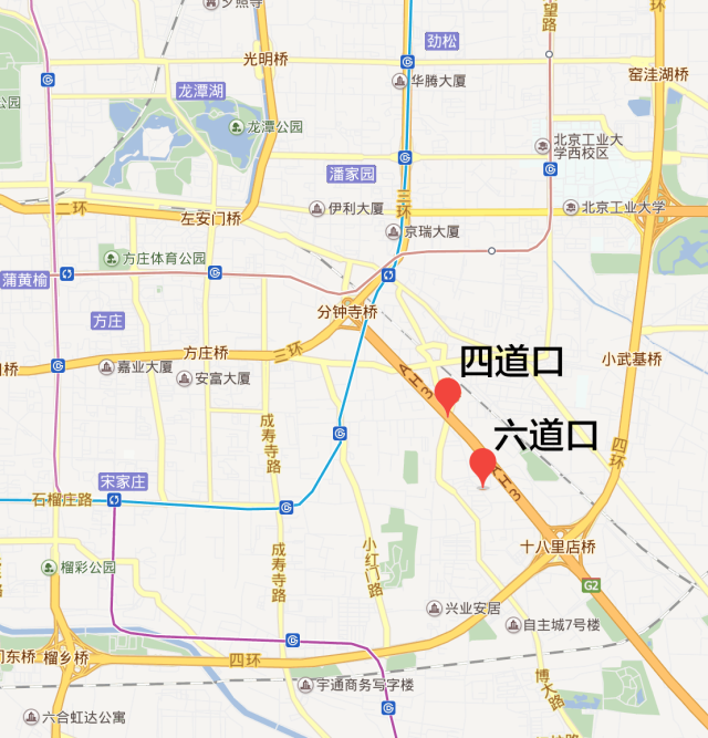
There are three places named Si Daokou in Beijing today. Two are in Haidian District—one near Beijing Jiaotong University and another near Baishi Bridge; the third is in Chaoyang District, about 8 kilometers due south of Ritan (Ritan Park).
According to the Gazetteer of Beijing Place Names (北京地名志), the Si Daokou north of Jiaotong University was once the intersection of two ancient routes: one from Xiaoximen to Landianchang, and the other from Xizhimen to Nankou. This intersection dates back roughly to the Yuan Dynasty.
There is another explanation circulating online: that this daokou was the fourth level crossing on the Jingzhang Railway (Beijing–Zhangjiakou Railway). According to the gazetteer, the Jingzhang Railway basically follows the same alignment as the old road from Xizhimen to Nankou just mentioned. At this point you might find the “fourth crossing” claim a bit odd, because the starting point of the Jingzhang Railway is Beijing North Railway Station (Xizhimen Station), so how could this possibly be the fourth crossing? To clarify this, I checked the Atlas of Administrative Divisions of Beijing and a few references on the Jingzhang Railway. The story goes like this:
The Jingzhang Railway was the first railway in China to be fully surveyed, designed, constructed, and operated by Chinese people without foreign funds or personnel. The line to Badaling is part of the Jingzhang Railway. If you’ve never taken this section, you should definitely make time to experience it. At Qinglongqiao Station, the train passes the “human-shaped” (人字形) switchback section we learned about in elementary school textbooks.
Today, the line officially starts at Beijing North Station in Xizhimen, but when the railway was first built, its actual terminus was Liucun Station in Fengtai.
The map below is an administrative map of Beiping from June 1949. On it, you can see the section of the railway from Fengtai to Xizhimen.
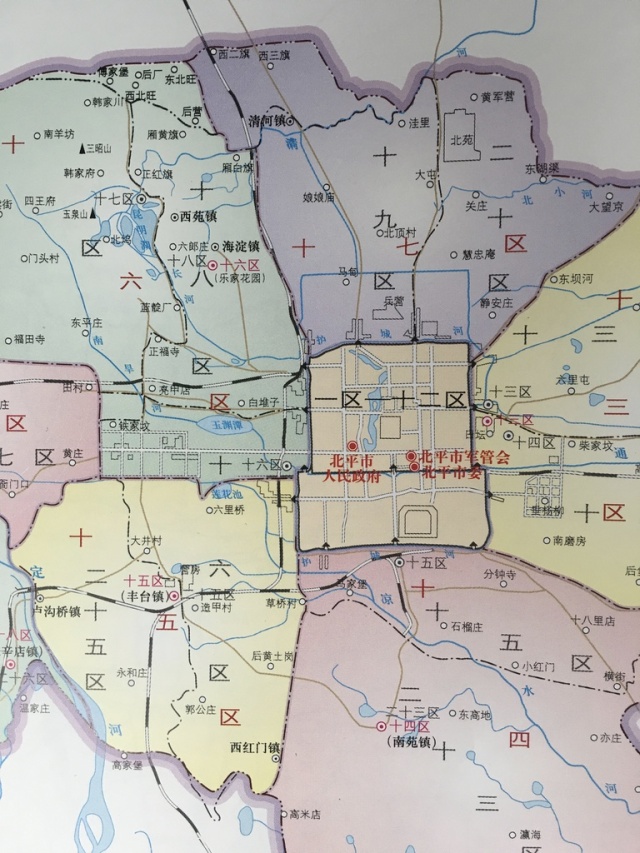
When the Jingzhang Railway was first built, all crossings with roads were level crossings. That is how these daokou came into being, and Si Daokou was the fourth of those crossings.
Later, due to road traffic needs, the section of the Jingzhang Railway from Fengtai to Xizhimen was dismantled in 1968. From then on, only Si Daokou and Wu Daokou remained along that stretch of railway.
The other Si Daokou in Haidian District is south of Baishi Bridge. The gazetteer does not explain the origin of this place name. However, following the same logic as above, I suspect it is related to another railway—the Jingmen Railway (Beijing–Mentougou).
The Jingmen Railway started at Chegongzhuang Station, south of Xizhimen, and ended at Mentougou Station. It served as an auxiliary line to the Jingzhang Railway and was originally called the Jingmen Branch Line. The purpose of this line was to transport coal from Mentougou to Xizhimen to fuel the steam locomotives on the Jingzhang Railway.
This railway can also be readily found in the map above, and the fourth level crossing along this line is today’s Si Daokou located just south of Baishi New Bridge.
There’s also an anecdote about this railway worth sharing. The section of the Jingmen Railway from Xizhimen to Wulu was ordered to be dismantled in 1971 (rumored to be by Premier Zhou Enlai) because it interfered with state guest motorcades traveling from Xiyuan Airport into the city. During demolition, the workers were reportedly so careless that they left a locomotive east of Wulu Station. That locomotive is now preserved inside Linglong Park, where you can still see it today.
Outside Haidian District, Chaoyang District also has a Si Daokou. About 8 kilometers due south of Ritan lies Si Daokou Village. According to the gazetteer, the village got its name because it sat at the intersection of four roads.
Wu (5th) Daokou
The gazetteer does not give the origin of the name Wu Daokou. A widely accepted explanation (repeated in various encyclopedic entries) is that this was the fifth level crossing along the Jingzhang Railway. We’ve already explained why Wu Daokou can indeed be the fifth crossing, so we won’t repeat that here.
When talking about Wu Daokou, we have to mention that many people call it the “Center of the Universe.” There are numerous discussions online about how this nickname came about. The most comprehensive summary is found in the article “Wu Daokou Really Is the Center of the Universe” (《論五道口果然是宇宙中心》). The author of that article is unknown; all existing versions on the internet appear to be reposts. The explanation I agree with most is this one:
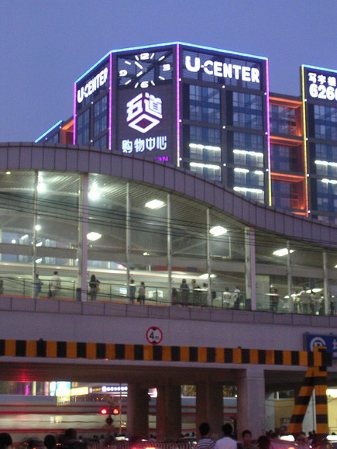
This “U-CENTER” really says it all.
Liu (6) Daokou
There are two places named Liu Daokou in Beijing: one north of Xueyuan Road in Haidian District, and the other southeast of Ritan in Chaoyang District.
Although Haidian’s Liu Daokou is north of Wu Daokou, it is not directly north of it. Even if we take into account the realignment of the Jingzhang Railway near Tsinghua, today’s Liu Daokou is still not on the former or current route of the Jingzhang line. So the earlier “railway crossing sequence” logic does not apply here.
According to the gazetteer, this area was originally Liu Daokou Village. The village was named because it lay at the intersection of three roads: a north–south route from Xizhimen to Qinghe; an east–west route from Shuangquanbao to Bajia; and a southeast–northwest route from Beishatan to Houbaijia.
Today’s Liu Daokou is left with only two roads: Tsinghua East Road and Xueyuan Road / Xueqing Road.
The Liu Daokou in Chaoyang District is very close to Si Daokou, located just a few hundred meters due south of Si Daokou. According to local records, it was originally the intersection of six roads, hence the name.
Due to limited sources, the information above may contain inaccuracies. Corrections and criticism are welcome. Special thanks to Xiao Ma’s Atlas of Administrative Divisions of Beijing (《北京市行政區劃圖志》), as well as Wikipedia, Gazetteer of Haidian District Place Names (《海淀區地名志》), and Gazetteer of Chaoyang District Place Names (《朝陽區地名志》).
Cover image: Train arriving at a railway station
Author: Ranmali Kirinde